


VSC Content Indicators and Objectives |
Cite and describe the processes that cause rapid or slow changes in Earth's surface. · Identify and describe events such as tornadoes, hurricanes, volcanic eruptions, earthquakes, and flooding which change surface features rapidly. · Recognize that the natural force of gravity causes changes in the Earth's surface features as it pulls things towards Earth, as in mud and rock slides, avalanches, etc. · Cite examples that demonstrate how the natural agents of wind, water, and ice produce slow changes on the Earth's surface such as carving out deep canyons and building up sand dunes. Explain how rock is formed from combinations of different minerals and that smaller rocks come from the breakage and weathering of bedrock (solid rock underlying soil components) and larger rocks; soil is made partly from weathered rock, partly from plant remains-and also contains many living organisms. · Color Identify and compare the properties of rocks that are composed of a single mineral with those of other rocks made of several minerals using their physical properties.
|
Vocabulary Words to Look Up and Put in your Journal
Erosion
Minerals
Igneous
Sedimentary
Metamorphic
Tornadoes Hurricanes
Volcanic Eruptions, Earthquakes
Flooding
Force
Gravity
Rock slides
Minerals
Physical Properties
Weathering
Luster
Hardness
Streak 1. Reshaping earth rapidly (floods, volcanoes, etc.)
2. Slow changes of the Earth’s surface (erosion and weathering)
3. Rocks and minerals
4. Comparing rocks composed of single minerals with rocks composed of more than one mineral
5. The Rock Cycle
What is a tornado?
A tornado is a violent rotating column of air extending from a thunderstorm to the ground. The most violent tornadoes are capable of tremendous destruction with wind speeds of up to 300 mph. They can destroy large buildings, uproot trees and hurl vehicles hundreds of yards. They can also drive straw into trees. Damage paths can be in excess of one mile wide to 50 miles long. In an average year, 1000 tornadoes are reported nationwide.
Main Idea
_________________________________________________
_________________________________________________
Detail#1__________________________________________________________________________
_________________________________________________________________________________
Detail#2__________________________________________________________________________
_________________________________________________________________________________
Detail#3__________________________________________________________________________
_________________________________________________________________________________
Assignment=Watch this video and take 15-20 notes from it in your journal
Most tornadoes form from thunderstorms. You need warm, moist air from the Gulf of Mexico and cool, dry air from Canada. When these two air masses meet, they create instability in the atmosphere. A change in wind direction and an increase in wind speed with increasing height creates an invisible, horizontal spinning effect in the lower atmosphere. Rising air within the updraft tilts the rotating air from horizontal to vertical. An area of rotation, 2-6 miles wide, now extends through much of the storm. Most strong and violent tornadoes form within this area of strong rotation.
 How do tornadoes stop? It is not fully understood about how exactly tornadoes form, grow and die. Tornado researchers are still trying to solve the tornado puzzle, but for every piece that seems to fit they often uncover new pieces that need to be studied.  Assignment=Please copy this graphic organizer in your journal and complete it from the 2 paragraphs of reading above. What is a supercell thunderstorm? A supercell thunderstorm is a long-lived thunderstorm whose updrafts and downdrafts are in near balance. These storms have the greatest tendency to produce tornadoes that stay on the ground for long periods of time. Supercell thunderstorms can produce violent tornadoes with winds exceeding 200 mph. What is a mesocyclone? A mesocyclone is a rotating vortex of air within a supercell thunderstorm. Mesocyclones do not always produce tornadoes.  What is a wall cloud? A wall cloud is an abrupt lowering of a rain-free cumulonimbus base into a low-hanging accessory cloud. A wall cloud is usually situated in the southwest portion of the storm. A rotating wall cloud usually develops before tornadoes or funnel clouds. 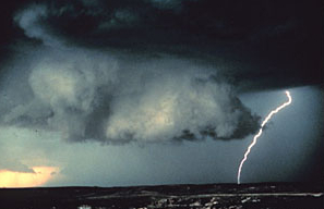 What is a waterspout? A waterspout is just a weak tornado that forms over water. They are most common along the Gulf Coast. Waterspouts can sometimes move inland, becoming tornadoes causing damage and injuries. 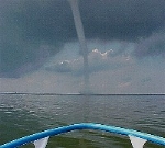 What is hail? Hail is created when small water droplets are caught in the updraft of a thunderstorm. These water droplets are lifted higher and higher into the sky until they freeze into ice. Once they become heavy, they will start to fall. If the smaller hailstones get caught in the updraft again, they will get more water on them and get lifted higher in the sky and get bigger. Once they get lifted again, they freeze and fall. This happens over and over again until the hailstone is too heavy and then falls to the ground. 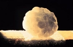 What is the largest hailstone recorded in the United States? According to the National Weather Service, the largest hailstone is 8 inches in diameter and weights approximately 2 pounds. It fell in Vivian, South Dakota on July 23, 2010. 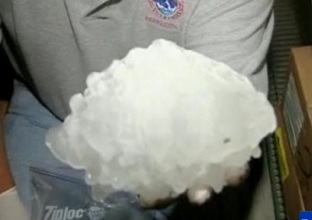 VOCABULARY
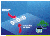
A gustnado is a short-lived, relatively weak whirlwind that forms along a gust front. A gust front is the surge of very gusty winds at the leading edge of a thunderstorm's outflow of air. Gustnadoes are not tornadoes. They do not connect with any cloud-base rotation. But because gustnadoes often have a spinning dust cloud at ground level, they are sometimes wrongly reported as tornadoes. Gustnadoes can do minor damage. What is a landspout? A landspout is a very weak tornado that is not associated with a wall cloud or a mesocyclone. It is the land equivalent of a waterspout. When are tornadoes most likely to occur? Tornadoes can happen at any time of the year and at any time of the day. In the southern states, peak tornado season is from March through May. Peak times for tornadoes in the northern states are during the summer. A few southern states have a second peak time for tornado outbreaks in the fall. Tornadoes are most likely to occur between 3 p.m. and 9 p.m. Where are tornadoes most likely to occur? The geography of the central part of the United States, known as the Great Plains, is suited to bring all of the ingredients together to forms tornadoes. More than 500 tornadoes typically occur in this area every year and is why it is commonly known as "Tornado Alley". 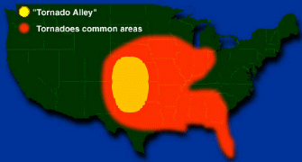 Vocabulary Assignment=Please copy this graphic organizer in your journal and complete it from the reading above.
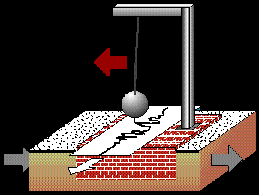
What is an earthquake? Earthquakes are the shaking, rolling or sudden shock of the earth’s surface. They are the Earth's natural means of releasing stress. More than a million earthquakes rattle the world each year. The West Coast is most at risk of having an earthquake, but earthquakes can happen in the Midwest and along the East Coast. Earthquakes can be felt over large areas although they usually last less than one minute. Earthquakes cannot be predicted - although scientists are working on it!  Click Here to learn more about earthquakes from USGS. Because people are frequently left relying on themselves for awhile after an earthquake, it is a good idea to have an earthquake survival kit ready. Everyone who lives in an area where large earthquakes can happen should have one of these kits in their home. What causes an earthquake? There are about 20 plates along the surface of the earth that move continuously and slowly past each other. When the plates squeeze or stretch, huge rocks form at their edges and the rocks shift with great force, causing an earthquake. Think of it this way: Imagine holding a pencil horizontally. If you were to apply a force to both ends of the pencil by pushing down on them, you would see the pencil bend. After enough force was applied, the pencil would break in the middle, releasing the stress you have put on it. The Earth's crust acts in the same way. As the plates move they put forces on themselves and each other. When the force is large enough, the crust is forced to break. When the break occurs, the stress is released as energy which moves through the Earth in the form of waves, which we feel and call an earthquake. (Graphic Credit: Wheeling Jesuit University/NASA Classroom of the Future) 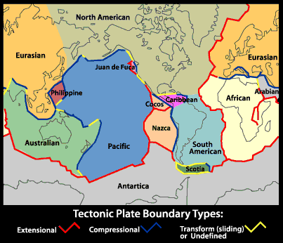 Assignment=Please copy this graphic organizer in your journal and complete it from the reading above about the causes of an earthquake. | 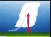 | 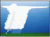 |
Click Here to see an animation of an earthquake. It's great for kids, because they get to see how it actually happens!
What is a fault?
A fault is an area of stress in the earth where broken rocks slide past each other, causing a crack in the Earth's surface. There are the major types of faults: dip-slip normal, dip-slip reverse, strike-slip, and oblique-slip.
What are plate tectonics?
The theory of plate tectonics is a interesting story of continents drifting from place to place breaking apart, colliding, and grinding against each other. The plate tectonic theory is supported by a wide range of evidence that considers the earth's crust and upper mantle to be composed of several large, thin, relatively rigid plates that move relative to one another. (See plate tectonic graphic above.) The plates are all moving in different directions and at different speeds. Sometimes the plates crash together, pull apart or sideswipe each other. When this happens, it commonly results in earthquakes.
The theory of plate tectonics is a interesting story of continents drifting from place to place breaking apart, colliding, and grinding against each other. The plate tectonic theory is supported by a wide range of evidence that considers the earth's crust and upper mantle to be composed of several large, thin, relatively rigid plates that move relative to one another. (See plate tectonic graphic above.) The plates are all moving in different directions and at different speeds. Sometimes the plates crash together, pull apart or sideswipe each other. When this happens, it commonly results in earthquakes.
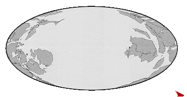 |
| Continental Drift: To see this animation again, just refresh this page! This animation shows you what our planet looked like millions of years ago and what it looks like now! (Graphic Credit: Geology Department at University of California, Berkeley) |
Assignment=Please copy this graphic organizer in your journal and complete it from the 2 paragraphs of reading above.
Click Here to learn more about plate tectonics and the drifting of our continents.
What is a seismograph?
A seismograph is an instrument used for recording the intensity and duration of an earthquake.
Click Here to calculate the strength of earthquakes!
VOCABULARY
Assignment=Please copy this activity in your journal and Complete each sentence using the words in the word list.
Complete each sentence using the words in the word list.
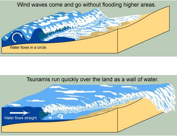
What is a tsunami?
A tsunami is a large ocean wave usually caused by an underwater earthquake or a volcanic explosion. Tsunamis are NOT tidal waves. Tidal waves are caused by the forces of the moon, sun, and planets upon the tides, as well as the wind as it moves over the water. With typical waves, water flows in circles, but with a tsunami, water flows straight. This is why tsunamis cause so much damage!
A seismograph is an instrument used for recording the intensity and duration of an earthquake.
Click Here to calculate the strength of earthquakes!
VOCABULARY
|
| 31. | ____ a process that causes rocks to gradually break or crumble into smaller pieces. | |
| 32. | ____ occur on fault lines. | |
| 33. | The Painted Desert has many colors caused by a wide variety of ____. | |
| 34. | Some rocks leave a black ____. | |
| 35. | Many ____ form in Kansas and Oklahoma. | |
| 36. | Polishing rocks brings out their ____. | |
| 37. | The stone had a bright ____. | |
| 38. | Farmers changed the way they planted wheat to prevent ____ of their land. | |
| 39. | We cracked open the geode and found the beautiful ____ inside. |
A tsunami is a large ocean wave usually caused by an underwater earthquake or a volcanic explosion. Tsunamis are NOT tidal waves. Tidal waves are caused by the forces of the moon, sun, and planets upon the tides, as well as the wind as it moves over the water. With typical waves, water flows in circles, but with a tsunami, water flows straight. This is why tsunamis cause so much damage!
Assignment=Please copy this graphic organizer in your journal and complete it from the reading above.
Main Idea
_________________________________________________
_________________________________________________
Detail#1__________________________________________________________________________
_________________________________________________________________________________
Detail#2__________________________________________________________________________
_________________________________________________________________________________
Detail#3__________________________________________________________________________
_________________________________________________________________________________
Click Here to see an animation of an earthquake and the resulting tsunami. It's great for kids, because they get to see how it actually happens!
Assignment- Explain exactly what happens in your journal, and why it happens?
Assignment- Explain exactly what happens in your journal, and why it happens?
Assignment- Please click this website and watch some Students' experiment about the power and destructiveness of a Tsunami
Assignment- Explain exactly what happens in your journal, and why it happens?
Know the Lingo 
EPICENTER - The point on the earth's surface directly above the source of the earthquake.
SEISMIC WAVES - The energy created by the quake travels in waves from the epicenter, where they are the strongest. The waves shake buildings, structures and the earth vertically, causing them to move horizontally!
RICHTER SCALE - A measurement of an earthquake's intensity. Each one-point increase on the scale indicates ten times the amount of shaking and 33 times the amount of energy. The energy released by a large earthquake may be equal to 10,000 times the energy of the first atomic bomb.
Click Here to see if there has been any recent earthquake activity across the U.S.
Richter Scale
Click Here to learn about cool earthquake facts!
EPICENTER - The point on the earth's surface directly above the source of the earthquake.
SEISMIC WAVES - The energy created by the quake travels in waves from the epicenter, where they are the strongest. The waves shake buildings, structures and the earth vertically, causing them to move horizontally!
RICHTER SCALE - A measurement of an earthquake's intensity. Each one-point increase on the scale indicates ten times the amount of shaking and 33 times the amount of energy. The energy released by a large earthquake may be equal to 10,000 times the energy of the first atomic bomb.
Click Here to see if there has been any recent earthquake activity across the U.S.
| 4 | Minor Earthquake |
| 5 | Moderate Earthquake |
| 6 | Strong Earthquake |
| 7 | Major Earthquake |
| 8 | Great Earthquake |
Click Here to learn about cool earthquake facts!
Assignment=Watch this video and take 15-20 notes from it in your journal
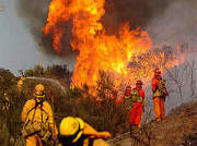
Wildfires
What is a wildfire?
A wildfire also known as a wildland fire, forest fire, vegetation fire, grass fire, peat fire, bushfire (in Australia), or hill fire is an uncontrolled fire often occurring in wildland areas, but which can also consume houses or agricultural resources. Wildfires often begin unnoticed, but they spread quickly igniting brush, trees and homes.
What causes a wildfire?
Common causes of wildfires include lightning, human carelessness, arson, volcano eruption, and pyroclastic cloud from active volcano. Heat waves, droughts, and cyclical climate changes such as El Niño can also have a dramatic effect on the risk of wildfires. Although, more than four out of every five wildfires are caused by people.
Assignment=Please copy this graphic organizer in your journal and complete it from the reading above.
Main Idea
_________________________________________________
_________________________________________________
Detail#1__________________________________________________________________________
_________________________________________________________________________________
Detail#2__________________________________________________________________________
_________________________________________________________________________________
Detail#3__________________________________________________________________________
_________________________________________________________________________________
Where can wildfires occur?
Wildfires can occur anywhere, but are common in the forested areas of the United States and Canada. They are also susceptible in many places around the world, including much of the vegetated areas of Australia as well as in the Western Cape of South Africa. The climates are sufficiently moist to allow the growth of trees, but feature extended dry, hot periods. Fires are particularly prevalent in the summer and fall, and during droughts when fallen branches, leaves, and other material can dry out and become highly flammable. Wildfires are also common in grasslands and scrublands.
If you live in an area where wildfires can happen, it really helps to have emergency supplies on hand. These can help to keep you, your family, and your pet's safe well after a fire has moved through the area.
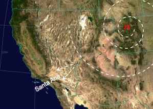
What are the Santa Ana winds?
The Santa Ana winds are hot, dry winds that aggravate the fire danger in forests and bush lands. These winds characteristically appear in Southern California and Northern Baja California weather during autumn and early winter. In southern California, under the influence of Santa Ana winds, wildfires can move at tremendous speeds, up to 40 miles in a single day, consuming up to 1,000 acres per hour. Dense clouds of burning embers push ahead of the flames crossing firebreaks without a problem.
Assignment=Please copy this graphic organizer in your journal and complete it from the reading above.
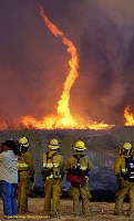
What is a fire tornado?
A fire tornado or fire whirl is just a tornado made of fire. It happens when certain conditions (depending on air temperature and currents), acquires a vertical vorticity and forms a whirl, or a tornado-like effect. Fire tornadoes may be whirlwinds separated from the flames, either within the burn area or outside it. A fire tornado can make fires more dangerous.
Assignment= Please explain in your journal what a wildfire is and how it can change how the land looks?
How do firefighters put out the wildfires?
Firefighters use a tool known as a pulaski. Its a combination of an ax and hoe used to dig a fireline. A fireline is a strip of land from which all brush and debris have been cleared to rob a wildfire of its fuel. Firefighters also use hotshots and smoke jumpers to clear a large path in a big circle around the fire so the blaze is contained in a ring of dirt. When the fire reaches this area, it runs out of fuel and starves to death. If the fire is too large, however, planes and helicopters fly overhead, dropping water and special chemicals that smother the flames. This pink, fire-retardant chemical is called sky jell-o.
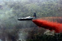
Assignment= In your journal, explain in your own words how firefighters put out wildfires.
Know the Lingo
SURFACE FIRES - The most common type of wildfires, surface fires move slowly and burn along the forest floor, killing and damaging vegetation.
GROUND FIRES - These are usually started by lightning, ground fires burn on or below the forest floor through the root system.
CROWN FIRES - These fires spread by wind moving quickly along the tops of trees.
SANTA ANA WINDS - "Santa Ana" is the name given to the gusty northeast or east wind that occurs in Southern California during the fall and winter months. Santa Ana winds are often hot and very dry, greatly aggravating the fire danger in forests and bush lands.
CONFLAGRATION - A large and destructive fire, typically aggravated by strong winds that carry firebrands over natural or artificial barriers.
Click Here to learn about more wildfire facts!
Assignment=Please copy this graphic organizer in your journal and complete it from the reading above.
VOCABULARY
|
| 1. | The ocean causes ____ at the cliff edge. | |
| 2. | Farmers changed the way they planted wheat to prevent ____ of their land. | |
| 3. | ____ formed the Grand Canyon. | |
| 4. | Forecasters try to foretell how many ____ we will have each year. | |
| 5. | ____ are found in alot of things we use everyday like salt for our food. | |
| 6. | The color of a mineral in powdered form is the ____. | |
| 7. | Heavy rainfall can make ____ happen. | |
| 8. | The wind and water caused much ____ of the land. | |
| 9. | The minerals with the greatest ____ is diamond. | |
| 10. | He used the ____ test to help identify the mineral. | |
| 11. | The Tectonic plates move slowly causing ____ and other changes. | |
| 12. | Her diamond ring had a shimmering ____. | |
| 13. | Polishing rocks brings out their ____. | |
| 14. | Nine ____ were predicted for the coming season. | |
| 15. | The residents received a dire warning from the meteorologist about the possibility of multiple ____. |
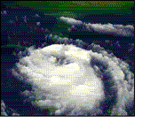
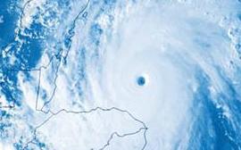
| Rain & Floods How does rain form? Water droplets form from warm air. As the warm air rises in the sky it cools. Water vapor (invisible water in the air) always exists in our air. Warm air holds quite a bit of water. For example, in the summer it is usually very humid. When enough of these droplets collect together, we see them as clouds. If the clouds are big enough and have enough water droplets, the droplets bang together and form even bigger drops. When the drops get heavy, they fall because of gravity, and you see and feel rain. 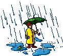 What causes rain? When clouds develop or rain occurs, something is making the air rise. Several things can make this happen. Mountains, low-pressure areas, cold fronts, and even the jet stream. How big are raindrops? Raindrops are much smaller than we think! They are actually smaller than a centimeter. Raindrops range from 1/100 inch (.0254 centimeter) to 1/4 inch (.635 centimeter) in diameter.  How fast do raindrops fall? Not including wind-driven rain, raindrops fall between 7 and 18 miles per hour (3 and 8 meters per second) in still air. The range in speed depends on the the size of the raindrop. Air friction breaks up raindrops when they exceed 18 miles per hour. What is a flood? A flood results from days of heavy rain and/or melting snows, when rivers rise and go over their banks. What is a flash flood? A flash flood is sudden flooding that occurs when floodwaters rise rapidly with no warning within several hours of an intense rain. They often occur after intense rainfall from slow moving thunderstorms. In narrow canyons and valleys, floodwaters flow faster than on flatter ground and can be quite destructive. Do flash floods hurt people? Flash floods are the #1 weather-related killer in the U.S. Nearly 80% of flash flood deaths are auto related. Know beforehand if your area is a flood risk. 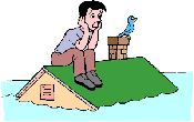 You can help protect yourself against the effects of heavy rain, which can cause flooding by having a preparedness kit. A preparedness kit helps you to stay safe until the floodwaters drain away, or until you're rescued. How much water is needed for your car to float away? A mere 2 feet of water can float a large vehicle or even a bus. This is why you should never drive through flooded roads. Just 6 inches of rapidly moving flood water can knock a person down.  What is radar? Radar is an electronic instrument, which determines the direction and distance of objects that reflect radio energy back to the radar site. It stands for Radio Detection and Ranging. This is what meteorologists use to see rain or snow. 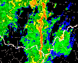 What is Doppler Radar? Doppler Radar detects precipitation intensity, wind direction and speed, and provides estimates of hail size and rainfall amounts. Doppler Radar gives forecasters the capability of providing early detection of severe thunderstorms that may bring strong damaging winds, large hail, heavy rain, and possibly tornadoes. Combined with satellites, radar gives forecasters the ultimate tools to provide accurate forecasts and advanced severe weather warnings. How does Doppler Radar work? Doppler Radar gets its name from the Doppler Effect. Have you ever listened to a train whistle as it was coming toward you? You probably noticed that the pitch of the whistle changed as the train passed you and moved away. This change in the frequency of sound is called the Doppler Effect. Doppler Radar measures the changes in the frequency of the signal it receives to determine the wind.  .  EROSION from water/floods Erosion By Water Processes We will examine erosion, and its effect on the landscape. Erosion takes place when materials in the landscape are moved from one location to another. This might happen as dust is blown off the side of a cliff face by wind, or as silt is carried downstream by a river. Erosion By Overland Flow Between valley’s at the top of interfluves water runs across the landscape in flat sheets known as overland flow. As rain drops begin falling in a rain storm they are first absorbed by the landscape. As the ground becomes saturated, the drops begin moving across the landscape above the surface. As this happens, small amounts of dust and dirt are carried with the water. This is known as splash erosion. As more and more water falls, the sheet of moving water becomes larger and larger.  Assignment=Please copy this graphic organizer in your journal and complete it from the reading above. Main Idea _________________________________________________ _________________________________________________ Detail#1__________________________________________________________________________ _________________________________________________________________________________ Detail#2__________________________________________________________________________ _________________________________________________________________________________ Detail#3__________________________________________________________________________ _________________________________________________________________________________ EROSION BY WATER Assignment=Watch this video and take 15-20 notes from it in your journal http://media.photobucket.com/video/water%20erosion/forbesscienceplus/Erosionbywater.mp4?o=1 Assignment= Please explain in your journal what is erosion and how it can change how the land looks?  Know the Lingo Know the LingoFLOOD WATCH - means that an overflow of water from a river is possible for your area. FLASH FLOOD WATCH - means that flash flooding is possible in or close to the watch area. Flash Flood Watches can be put into effect for as long as 12 hours, while heavy rains move into and across the area. FLOOD WARNING - means flooding conditions are actually occurring in the warning area. FLASH FLOOD WARNING - means that flash flooding is actually occurring in the warning area. A warning can also be issued as a result of torrential rains, a dam failure or snow thaw. Click Here to see if there are any active warnings in your area. Flood Safety TipsBEFORE A FLOOD: Have a disaster plan and prepare a disaster supplies kit for your home and car. Include a first aid kit, canned food, can opener, bottled water, battery-operated radio, flashlight, protective clothing and written instructions on how to turn off electricity, gas, and water. DURING A FLOOD: Move to a safe area quickly. Move to higher ground, like the highest floor of your home. Avoid areas subject to sudden flooding like low spots and canyons. Avoid already flooded areas. If a flowing stream of water is above your ankles stop, turn around and go the other way. Do not attempt to drive through a flooded road. The depth of the water is not obvious and the road may be washed away. If your car stalls, leave it and seek higher ground. Rapidly rising water may engulf the car, pick it up and sweep it away. Kids should never play around high water, storm drains or viaducts. Be cautious at night, because its harder to see flood dangers. If told to evacuate, do so immediately. AFTER THE FLOOD: Always, boil drinking water. Electrical equipment should be checked and dried before used. Rain ActivitiesHurricanes What is a hurricane? A hurricane is a huge storm! It can be up to 600 miles across and have strong winds spiraling inward and upward at speeds of 75 to 200 mph. Each hurricane usually lasts for over a week, moving 10-20 miles per hour over the open ocean. Hurricanes gather heat and energy through contact with warm ocean waters. Evaporation from the seawater increases their power. Hurricanes rotate in a counter-clockwise direction around an "eye." The center of the storm or "eye" is the calmest part. It has only light winds and fair weather. When they come onto land, the heavy rain, strong winds and large waves can damage buildings, trees and cars. 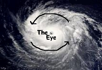 Assignment= Please explain in your journal what a hurricane is and how they can change how the land looks? Click Here to get your very own Hurricane Tracking Chart. How do hurricanes form? Hurricanes only form over really warm ocean water of 80°F or warmer. The atmosphere (the air) must cool off very quickly the higher you go. Also, the wind must be blowing in the same direction and at the same speed to force air upward from the ocean surface. Winds flow outward above the storm allowing the air below to rise. Hurricanes typically form between 5 to 15 degrees latitude north and south of the equator. The Coriolis Force is needed to create the spin in the hurricane and it becomes too weak near the equator, so hurricanes can never form there. (Graphic Credit: UCAR) 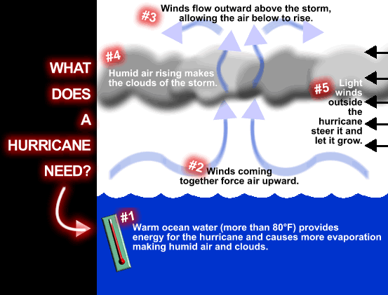
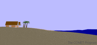
Click Here to learn more about hurricanes from UCAR. What is storm surge? Storm surges are frequently the most devastating element of a hurricane. As a hurricane’s winds spiral around and around the storm, they push water into a mound at the storm’s center. This mound of water becomes dangerous when the storm reaches land because it causes flooding along the coast. The water piles up, unable to escape anywhere but on land as the storm carries it landward. A hurricane will cause more storm surge in areas where the ocean floor slopes gradually. This causes major flooding. As you watch the storm-surge animations, notice the effect that the physical geography of each coastline has on storm surge. Also, note the waves on top of the ocean's surface. Wind, waves, and sea-level rise all contribute to storm-surge damage.
|  | |||||||||||||||||||||||||||||||||||||||||||||||||||||||||||||||||||||||||||||||||||||||||||||||||||||
 1
1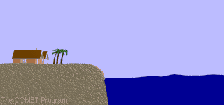 2
2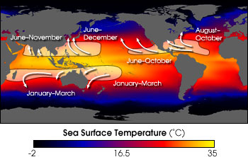


 Hurricanes...Past and Present
No comments:
Post a Comment